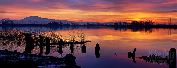
Delta Sunset
This inverted river delta is formed by the convergence of four California rivers, the Sacramento River from the north, the San Joaquin River from the southeast, as well as the Mokelumne and Calaveras Rivers (tributaries of the San Joaquin River) from the east. In all, the area consists of 57 reclaimed islands and tracts and over 1,100 miles of levees. Once a tidal marsh, this region is today one of the largest estuaries in North America and is home to 500 species of plants and animals.
Today, the Delta is an important source of recreation to local residents who take to these waters year-round for fishing, boating, camping, parasailing, waterskiing, and much more.
As a photographer, I have learned to look for fisherman parked along the levee roads as a clue to find access points to the riverbanks. Sometimes when I approach, I hear them shout "fish and game!" and they sometimes hide in the dense bamboo thickets. Oh boy, just how much does that fishing license cost? :)
This is a 5-frame pano, single exposure, stitched using Photoshop. That is majestic Mount Diablo on the distant horizon. Lens is the FA 150mm f/4 on the Pentax 645D. You can't tell from this photo, but I was actually standing in about 2 ft of muddy water for this photo, wearing the wading boots my wife bought me for my birthday! Often I am barefoot and can feel little creepy crawlies moving around under my feet, so to have my feet stay dry and NOT freezing was a real treat.
I hope you like it.